
Long before recorded history, the nomadic
creatures of the earth, known as man, created permanent homes. These
may have been caves, grass huts, mud shelters or huge
architectural undertakings.
No matter what the individual called home, it was deemed
to be a possession worthy of defending, and in many cases, the
defender lost both property and life. The
human desire to own a little patch of ground has not diminished
with time.
It
appears to be one of the principal goals of any individual and
is touted as being the most important and largest investment
encountered in a lifetime.
The history of land ownership is an
interesting study on its own and one that should be reviewed in
order to understand its development. The evolution of the
property conveyance in recent history has progressed from
passing a handful of dirt from the grantor to the grantee
(livery of seisin), noting the conveyance in writing (The
Statute of Frauds, 1677 A.D.), to the unique concept of digital
transfer (Land Registration Act). No matter what the
method of conveyance or the rules that govern such a
transaction, one element remains the same -- the land.
Title to land is conveyed by a deed, which is a document that transfers ownership. A description of the parcel forms a necessary part of the deed in the property conveyance. When an automobile is sold, the serial number, along with the make and model, is noted on the bill of sale. When land is the subject of the transaction, a description of the parcel is attached and is commonly referred to as the legal or property description.
The goal of any description is to be as
factual and accurate as the situation might demand. To
simply describe the land as "all the land that I own in
Hubbards" or "my property on Smith Street" is not sufficient.
The description is required to "be descriptive". In other words, it should cite a location,
reference document, boundary limits and area. The description,
without these simple elements, could create ambiguity with
respect to the extent of title. Such a result is not in the best
interest of the titleholder or the community.
Metes and Bounds
Property descriptions have developed certain
terminology over time and it is important to understand what
these terms mean. The term 'metes and bounds' description is
often referred to as being the desired form, but what does it
mean?
If your description was a 'bounds' description, it may read as follows: "on the north by Smith, on the east by Brown, on the south by Jones and on the west by Green". An area generally accompanies this type of description, but it is not descriptive of the parcel, other than indicating that it appears to be a four-sided figure. The resulting extent of title remains dependent upon the successful interpretation and location of the neighbours' boundaries.
The 'metes' description is more descriptive
of the parcel's configuration and is generally the result of a
survey, or an on-site investigation of the parcel being
conveyed. This requires both course and
distance be provided. An example may be as follows: "thence
easterly for a distance of 400 feet to a point".
If the phrase had been quoted as "thence easterly for a distance of 400 feet to the western boundary of Brown", the description becomes a 'metes and bounds' description. The concern in such a description, or any description for that matter, is to ensure that ambiguity has not been introduced into the boundary limit equation. One hopes that the description of the westerly limits of the Brown property will coincide with the terminal point created by the 400 feet easterly course.
Should the description have cited a
monument call at the end of the 400 feet? The answer is yes and
no. If a monument at the terminal point is to be mentioned, it
needs to be coincident with both course and direction, and also needs to be recognized by adjacent owners as marking the
corner. Oftentimes the original monument call has been
disturbed, replaced by another object, or no longer exists. This
creates another concern when the extent of title is to be
re-established and has been subject material for many court
cases and textbooks.
Understanding the Description
Description accuracy is a must if boundaries are to be established and recognized by owners. This requires an understanding of what constitutes acceptable wording and its interpretation. First and foremost, a description should be based on survey that is a true reflection of both site conditions and title records. To base a description on anything else introduces the possibility that the intent of the document cannot be fulfilled. If the course descriptions are based on poor or inaccurate information, the 'point of beginning' cannot be reached after traversing the various courses of the parcel. This is often the case when dealing with ancient surveys or 'kitchen table' descriptions.
A common element of any description is the 'point of beginning'. This should be adequately described and capable of being established without great difficulty. "Beginning at the north-easterly intersection of King and Queen Street, marked by an iron bar" may suit the situation. but only if the recognized intersection and the iron bar are deemed to be the same point. Another common element is direction. Directions are geographically referenced and can be referred to by such terms as 'true north', 'astronomic north', 'magnetic north' or 'grid north'. They all have unique referencing origins, but their usage and interpretation in a description are the same.
True north and astronomic north are generally determined by an astronomic observation of the sun or star with the appropriate calculations. The magnetic north is reference to the Magnetic North Pole and its relationship to true north varies with the geographical location of the observation. Local magnetic attractions can also result in anomalous readings. Grid north is the term used when the bearings are referenced to a local or recognized map projection. 'Grid bearings' are referenced to the central meridian (longitude line) of the projection. The map projection results in an exaggerated grid of longitude lines that in reality is coincident at the North Pole.
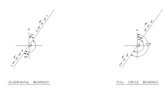
No matter what the bearing reference is, there are two types of bearings used in property descriptions and both are acceptable methods, but need to be understood. The first is quadrant bearings such as NE, SE, SW and NW, each containing a maximum of 90 degrees for a total of 360 degrees. The bearing is always the angle as measured left or right of north or south (see diagram 1). The second is the full circle bearing, which is measured from 0 to 360 degrees (see diagram 2). The major difference in the use of these two methods is the understanding of the reverse direction aspect. Quadrant bearings are simply a reversal of the quadrant such as NE for SW or SE for NW without a change to the numerical value. The full circle bearing requires a change to the numerical value by 180 degrees if the direction is reversed.
DIAGRAM 1 DIAGRAM 2
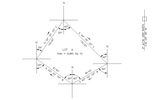
One can follow a description around its various courses by referring to the survey plan or creating a rough plot as the description is read (see diagram 3). As previously stated, the description must be accurate or its value is diminished. The goal of any description that has its courses defined by both direction and distance is to create a mathematically closed figure. This generally can't be done without the help of a land surveyor, unless a simple polygon is being dealt with.
DIAGRAM 3
Distances are also a common and essential element of the description. Course measurements can be provided in either imperial or metric values. It is also important to have knowledge of measurement units common to your geographical area. The chain and rod are common units of measure previously used. A chain is 66 feet in length and contains 100 links. A length of 1.5 chains x 66 feet = 99 feet. A rod equals 16.5 feet, or 25 links and 4 rods = 1 chain. 1 chain (66 feet) x 10 chains (660 feet) = 1 acre (43,560 square feet). Accuracy of measurement is critical in the creation of a description.
Extent of Title
While the lawyer deals with the 'quality of title', it's the land surveyor who provides the opinion on 'extent of title'. Both professions are authorized and regulated by statute law. The Land Surveyors Act in Nova Scotia deals with this issue under Interpretations, Section 2 subsection (ad), and gives the following definition:
2 (ad) "professional land surveying" means the advising on, the reporting on, the supervising of and the conducting of surveys to determine the horizontal and vertical position of any point and the direction and length of any line required to control, establish, locate, define or describe the extent or limitations of title;"
The drafting of a property description would appear to fall within the definition of "professional land surveying" since it's advising and reporting on the extent or limitations of title in written form. Unqualified individuals, however, frequently prepare property descriptions. Some are an attempt to amend an older description to more accurately reflect current ownership; some are based on subdivisions not under the seal of a land surveyor, while some are based on a recent survey plan. There is a risk that the written description will not accurately reflect the intention of the plan if interpretation of the extent of title is left to a layperson. The problem can be compounded if a non-professional also creates the plan.
A responsible public registry assists in the protection of ownership rights. The legal and survey professions work together as guardians of the registry, in an attempt to ensure that the deed/property description, survey plan and ground evidence forms a transparent overlay. Only then can you come close to defining extent as per description when an owners states "I just want what's in my deed, no more, no less".
Fred Hutchinson was the Executive Director of the Association of Nova Scotia Land Surveyors from 1999 to 2019 and is a Past President of the Association. Mr. Hutchinson was licensed in 1971, employed by municipal government for nearly six years and spent over twenty-two years in private practice.
